Zion National Park is just south of Bryce Canyon on the Interstate #15 and is quite an overwhelming area - as the first discoverers of it were the Mormon settlers who moved into the area, the names of everything is biblical based. From the bottom of the canyon to the top of the peaks is a distance of over 5000 feet so as you stand below and look straight up, it is very hard to convey feelings,
and to photograph it - it is sooo large in scale!


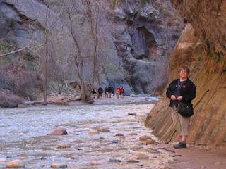
the bottom of the canyon and the Virgin River... this innocent little stream is the very river responsible for all the erosion in this canyon over hundreds of millions of years.
Zion Canyon reveals many events of middle geologic times. The story of Zion begins where that of Grand Canyon ends and ends where that of Bryce canyon begins. The geologic records of 2 billion years are incorporated in these three park areas, all located within 120 miles of each other.
But the part of this park that really blew us away was coming in through the East Entrance on the Mt. Carmel Highway. We drove through 2000 - 3000 foot tall sand dunes that had been frozen in time and turned into stone - the fluidity and organic quality of these was truly amazing. Unfortunately the road was so narrow that we didn't have any opportunity to take photos - we were too busy with our mouths gaping open and driving along.
Heading south from the park we drove through the Nevada desert and passed through a Joshua Tree cactus field. We had visited
Joshua Tree National Park in the southern California desert about ten years ago and this was reminiscent of those times.

Las Vegas - we spent 1 and 1/2 days going in and out of every hotel and casino on the Strip. I had had no desire to go to LV but my husband wanted to show me the glitz in the desert and on our full day we managed to pound the pavement for 14 hours straight and lose 25 cents in an arcade. Ow, ow for our poor feet...
the hotel PARIS

NEW YORK, NEW YORK

inside the VENETIAN (over the top Italian mastery - and the Travelocity gnome!)

But we did manage to do it right and save the best for last - the last hotel we entered was the BELLAGIO. This is the largest five-star hotel in the world, and everything about it is an expression of elegance. The entrance features 2000 glass flowers filling the ceiling by famed Seattle glass artist Dale Chihuly.

The botanical gardens employ 140 horticulturists who theatrically arrange gazebos, bridges, ponds, and water features uniquely for each season. And this area also includes a butterfly conservatory.

As we were driving out of Las Vegas down a back road we came across this building - at first we thought it had been burnt and had fallen into itself.

But as we approached it and could see more details it became an amazing deliberate design piece - and by
Frank Gehry, no less!


Still heading south, our route took us over the Hoover Dam. But as we were driving towards it we noticed a new 4-lane divided highway was being built alongside the road we were travelling on, and wondered if it was possible for them to build a bridge over, or beside the 80 years old dam. As we approached the actual dam, we found our answer.
As a civil engineer in my past life, I was much more interested in this "in action" process than the dam itself. As we drove across the single lane in each direction road, I was too busy snapping photos of the new bridge to even notice I was on a historical dam! Our timing was incredibly lucky to get these shots in progress...
The highway is the black line on the upper right, and the suspension lines are holding the arch of the central part of the construction. They are pouring concrete for the central arch in sections with the machinery at the top of the arch (on each side.)


And it wasn't until we crossed and stopped at a viewpoint high above on the other side that I got a good shot of the dam itself.


 As we left Las Vegas we headed south and then west on the #78. This route took us through the Algodones Dunes - an area of 8 by 40 miles, a vast pile of pure, golden sand, center of which has absolutely no vegetation and presents a stark, elemental scene of just two components - cloudless blue sky above and unbroken sandy mounds beneath.
 and the Anza-Borrego Desert State Park (where the above cactus photos came from) as we made our way to the Pacific coast, Encinitas and Santa Luz to spend a couple of days visiting with family.


